KCP - Botswana
The Kalahari Copper Belt Project (KCP) is located in northern Botswana's Kalahari Copper Belt, encompassing fourteen exploration licenses over 4,268 km².
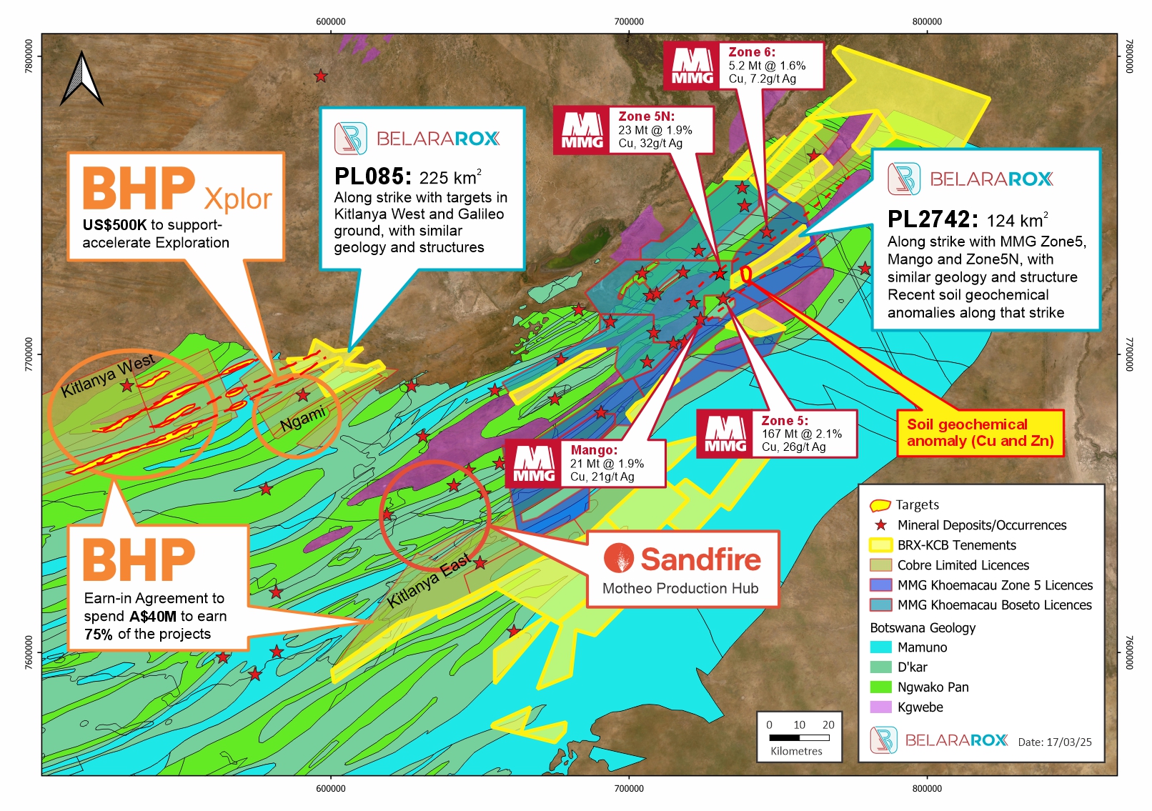
Location of licenses within the KCP
This area features highly prospective geology, hosting several world-class sediment-hosted copper-silver deposits, with sedimentary and volcanic suites forming the Mesoproterozoic-Neoproterozoic Ghanzi-Chobe belt, extending NE-SW for about 500 km. (Modie, 1996) The mineralization inside the belt is hosted within the Meso-Neoproterozoic Ghanzi Group, especially in the lower part of the D’Kar Formation near the contact with the Ngwako Pan Formation. The Ghanzi Group overlies the Kgwebe Volcanics and broadly consists of a 5-10km thick sequence comprising the Kuke Formation, Ngwako Pan Formation, the D’Kar Formation, and the Mamuno Formation from top to bottom.
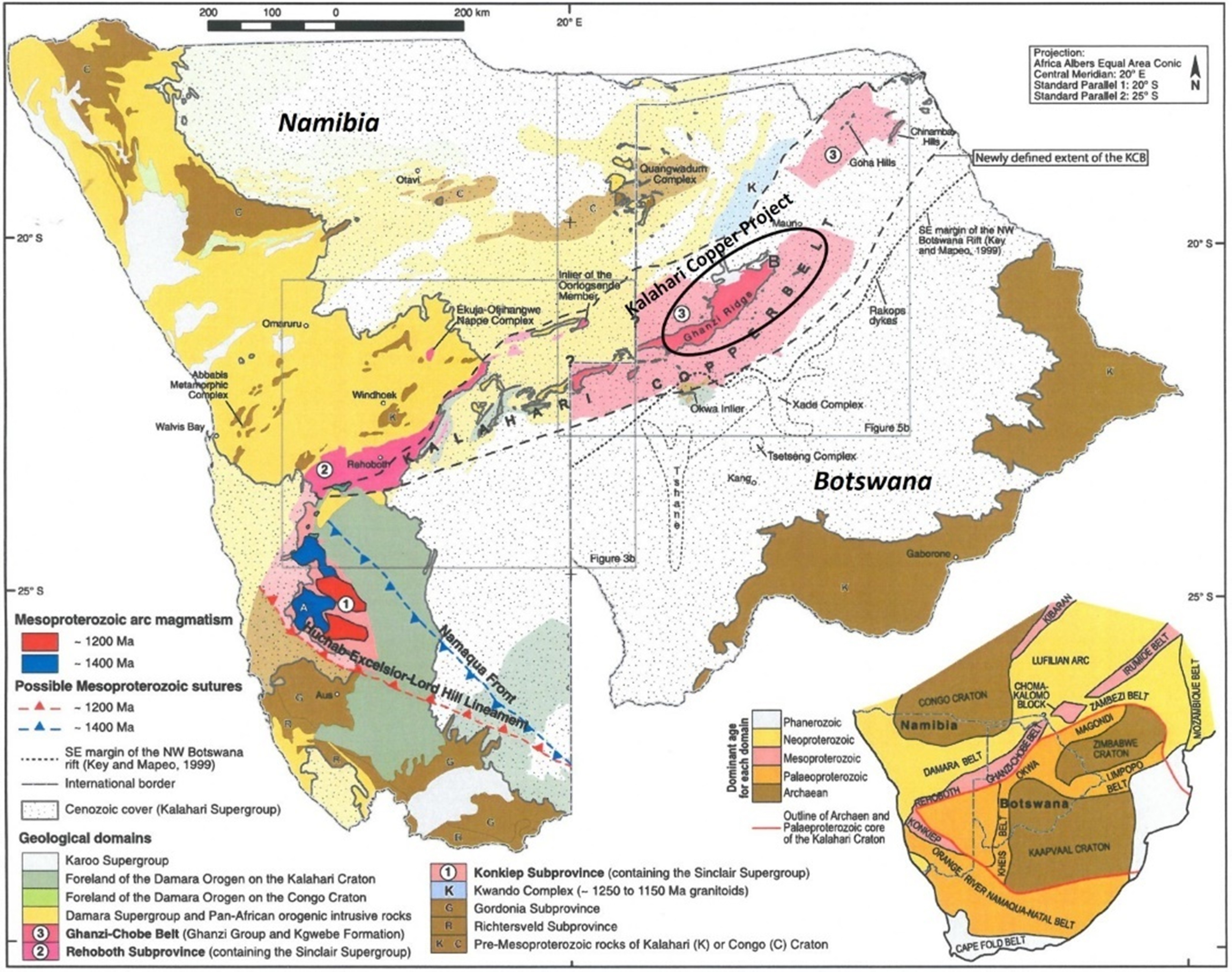
Regional geological setting of the Kalahari Copper Belt Project modified after Lehmann et al. (2015) and Robertson (2024).
A prime terrane with a known endowment of over 8 million tonnes of Cu
The Kalahari Copper Belt contains many world-class, sediment-hosted Cu-Ag deposits grouped in camps such as the Khoemacau and Motheo clusters. Deposits are generally confined near the interface Ngwako Pan formation and D’Kar Formation but also controlled by structures. It is zoned from chalcocite-bornite to chalcopyrite-pyrite. The fluid that brought the mineralisation is supposed to have derived from the basement and migrated through faults within the basement and along the stratigraphy. It is generally found at the limb of anticlines.
Several parameters controlled the presence of mineralisation and are used for exploration. These include:
- The Kwebge Volcanics as the source rocks for the metalliferous fluids.
- Preservation of the Ngwako Pan Formation – D’Kar Formation contact.
- Faults as metalliferous conduits to facilitate the transportation of metalliferous fluids.
- Sites with extension structures and anticlines in proximity with basement faults, for concentration of mineralising fluids and ore formation.
Prioritisation
An independent review using Sentinel-2 and Advanced Spaceborne Thermal Emission and Reflection Radiometer (ASTER) data was completed. This allowed the mapping of main structures and the distribution of minerals, discriminating against the areas covered with thick sand and outcrops. Further prioritization was achieved by reinterpreting publicly available geophysical data, including magnetic and gravity data from the Botswana Geoscience Institute. Priority was given to the tenements situated along the central corridor, where most deposits are known, and soil sampling has been successfully conducted.
An audio-frequency MagnetoTelluric (AMT) survey is planned to look deeper for structures and geology and assess the cover thickness. Airborne Electromagnetics (AEM) and ground-based gravity together with Aircore drilling have been planned. The Aircore program is designed to sample the top of bedrocks especially for areas under cover. This will constitute the target generation and target definition stages before considering drill testing of the best targets.
In the Fraser Institute’s 2023 Annual Survey of Mining Companies, Botswana was the highest-ranked African nation, placing 15th out of 86 jurisdictions globally in the Investment Attractiveness Index (IAI). (businessweekly.co.bw) (miningweekly.com) Botswana consistently ranks as one of Africa’s premier mining investment destinations, owing to its stable political environment, favorable mining policies, and rich mineral resources.